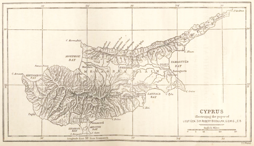
The island of Cyprus is the third largest in the Mediterranean, being inferior in size only to Sicily and Sardinia. Its area is 3584 square miles. Its principal features are two mountain ranges, running pretty well parallel to each other from east to west. The northernmost of these two ranges extends almost the whole length of the island from Cape Kormakiti on the north-west to Cape St. Andrea at the end of the horn-like promontory which stretches for 40 miles from the north-east of the island. This promontory is called the Carpas, and the low mountain chain running through it is called the Carpas range. The westernmost and higher portion of the northern range is called the Kyrenia range, and rises to an altitude of 3340 feet. This range is of a remarkably picturesque outline, in some parts extremely rugged. It is mostly a single ridge without any remarkable spurs, and its summit is about two miles from the northern coast. It can be crossed in many places, but there are three well-defined passes over it, viz. the Akatou Pass, which separates the Kyrenia and Carpas ranges; the Kyrenia Pass, which is due south of the town of Kyrenia, and forms the approach to it from Nicosia; and the Myrtou Pass, further west. The chief mountain peaks of this range are Kornos, 3105 feet; Buffavento, 3140; and Pentedaktylos, 2400. The last named is a remarkably shaped rock in the centre of the Kyrenian range, owing its name to its shape, the word Pentedaktylos signifying in Greek five-fingered. Beneath this rock there rushes out southward from the mountain side, at an altitude of 870 feet, a torrent of water, which never ceases to flow summer or winter, and which descending into the great plain in the centre of the island, carries its fertilising streams to the lands of several villages, its course marked by mills, gardens, and trees, until its water is exhausted by various irrigating channels. The principal village watered by this stream is called in Greek Kythrea, and in Turkish Deyrmenlik (the place of mills). It is situated about 10 miles to the north-east of Nicosia.
A similar stream of water gushes from the northern side, about 12 miles west of the Kyrenia Pass, above the village of Lapithos, which, with the adjoining village of Caravas, are probably the most prosperous villages in the whole island. Smaller streams descend on either side of the range at various placestheir waters are used for irrigation in the valleys.
The southern range of mountains is of a much more extensive nature than the northern range, which I have just been describing. The easternmost point of this range is the mountain of Santa Croce, so called from the church of the Holy Cross which stands on its summit. This mountain, which is 2260 feet in height, is of a peculiar shape, and from its isolated position it forms a prominent landmark, not only for vessels approaching the port of Larnaca, but also for those entering Famagusta. Beginning then from this point the southern range rapidly rises to considerable altitudes, finally culminating in Mount Troodos, the highest point in Cyprus, 6406 feet above the sea-level. The other chief peaks in the southern range are, Adelphe, 5305 feet, and Machera, 4674 feet. But it is not only in altitude that the Troodos range is distinguished; numerous spurs run down to the north and south, and as we proceed further west these radiate out to greater distances, so that half way between Troodos and the sea, the mountain range is not less than 20 miles wide. Here there are very considerable forests, many miles in extent, rarely visited save by wandering flocks and by wood-cutters, and affording shelter to the moufflon, or wild sheep of Europe, some 200 or 300 of which still roam over these hills.
On the map it will be seen that numerous rivers descend from both sides of the southern range. These are mostly dry in summer, but after rain their waters descend with violence, filling up the river-beds in the plains, carrying away trees and cultivated patches, and often rushing in a turbid stream into the bays of Famagusta and Morphou.
|