|
|
| |
| |
| |
|
| |
 |
| |
|
| uses Google technology and indexes
only and selectively internet - libraries
having books with free public access |
|
 |
|
|
 |
|
| |
|
| |
Previous | |
Next |
|
 |
SIR SAMUEL WHITE BAKER
CYPRUS AS I SAW IT IN 1879
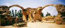
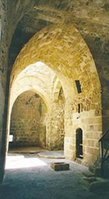
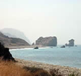
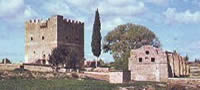
page 10 View PDF version of this page leading nations of the world were in ancient days undeniable. When vessels directed their course only by well-known landmarks, or by the position of certain stars, it was highly necessary for a maritime power to occupy a continuous chain of stations, where, in case of danger from a superior force, a place of refuge would be near. Cyprus from its peculiar geographical position commanded the eastern portion of the Mediterranean. The harbour of Famagousta was only a few hours' sail, with a favourable wind, to the coast of Asia Minor. The bays of Larnaca and Limasol were roadsteads with a safe anchorage, and Paphos (Baffo) was a convenient harbour upon the south-western portion of the island, capable of protecting a considerable number of the small vessels of the period. Thus Cyprus possessed two harbours upon the south coast in addition to good roadsteads ; while upon the north, Cerinea (Kyrenia) and Soli, although never large, were serviceable ports of refuge, exactly facing the coast of Caramania, plainly visible. The lofty mountains of the Carpas range which overhang these harbours command the sea view at an elevation of between three and four thousand feet, from which the approach of an enemy could be quickly signalled, while the unmistakable peaks of the rugged sky-line formed landmarks by which vessels could steer direct to the desired ports. The same advantage of descrying an enemy at a distance from the shore exists in many parts of Cyprus, owing to the position of the heights ;
View PDF version of this page
|
|
| |
Previous |
First |
Next |
|
|
|